The Master Plan
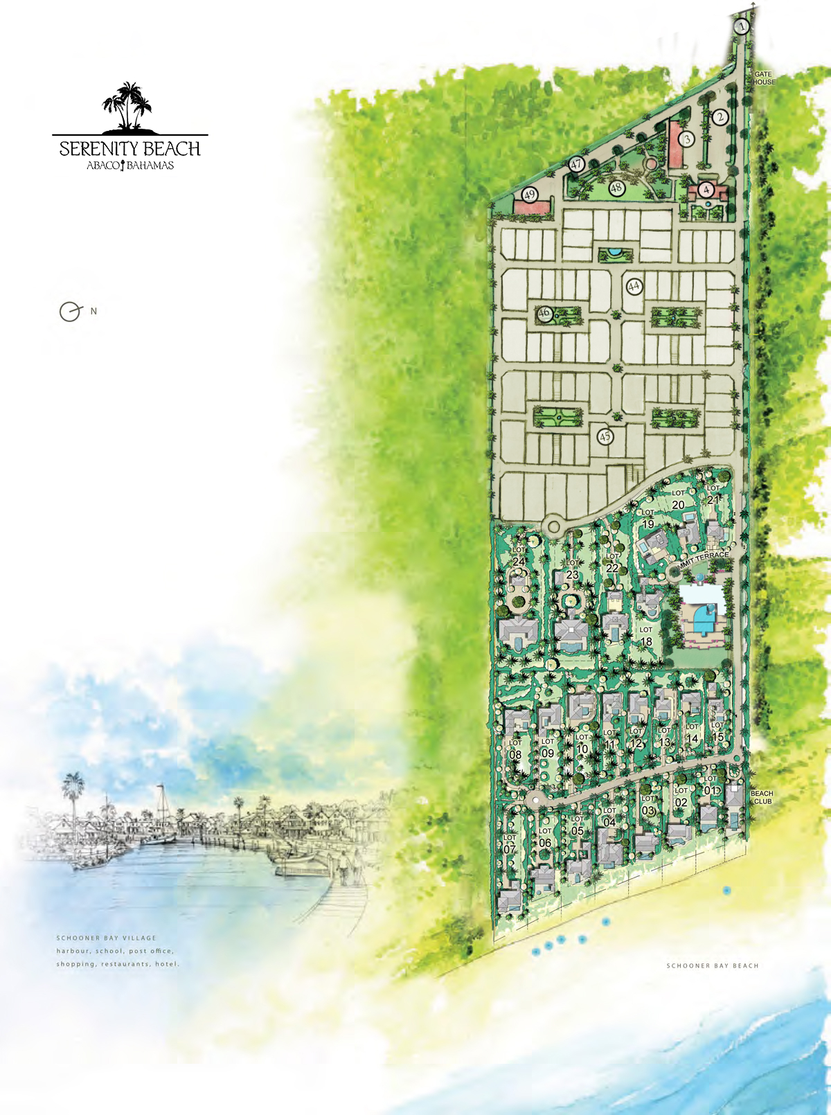
Serenity Beach fronts a bay that runs two miles of unbroken sand on the Atlantic coast of Great Abaco. The site holds approximately forty acres of that frontage, approximately 815 feet of it directly on the beach, with natural elevations to about 60 feet. The approved master plan provides 98 freehold residences across four tiers, Beachfront, Oceanview, Vista and Village Villas, and a nine-key boutique resort with clubhouse, beach club, spa and dining. Phases One and Two, the twenty-two recorded homesites described below, are the first stage of that plan.
The land rises from the shore in three distinct terraces. Sea oats and bay geranium hold the dunes. Behind them the ground climbs to a ridge that carries a view across the width of the island — the Atlantic to the east, the Marls to the west. The easterly breeze is near-constant.
Three positions
Beachfront. Seven parcels, approximately 10 to 20 feet above sea level, each with roughly 90 to 112 feet of direct beach frontage. Parcels run from about 21,000 to 47,400 square feet.
Oceanview. Eight parcels on the middle terrace, approximately 10 to 45 feet in elevation, 70 to 99 feet wide, from about 20,000 to 37,200 square feet.
Vista. Seven parcels on the ridge at approximately 30 to 70 feet, the highest ground in this part of Abaco. Dual aspect: sunrise over the Atlantic, sunset over the Sea of Abaco. From about 23,100 to 72,300 square feet — the largest positions in the plan.
The plan is drawn so that every parcel is oriented toward the beach. See the full parcel schedule with dimensions.
What surrounds it
Schooner Bay. A 320-acre village master-planned in 2006 by DPZ CoDesign, organised around what its planners identified as the only harbour opportunity on Abaco’s Atlantic coast for twenty miles in either direction. Serenity Beach adjoins Schooner Bay. It is a separate, independently owned development, is not part of Schooner Bay, and DPZ CoDesign has no involvement in Serenity’s planning. Ownership at Serenity does not confer rights in Schooner Bay’s harbour or amenities.
Abaco National Park. 20,500 acres established in 1994 and held by the Bahamas National Trust, protecting the only ground-nesting population of the Bahama Parrot — a species listed on CITES Appendix I and protected under the Wild Birds (Protection) Act.
The Marls. A wilderness flats system of more than two hundred square miles on Abaco’s western side, consistently ranked by lodge operators among the most productive bonefisheries in The Bahamas.
Marsh Harbour. The commercial centre of the Abacos, roughly thirty minutes north by road. Leonard M. Thompson International Airport is served by several carriers, with daily direct service from Miami, Fort Lauderdale, West Palm Beach, Orlando, Atlanta and Charlotte, and from Nassau, through a recently completed international terminal. Florida is a one-hour flight. Air service and schedules change; confirm current routes directly with the carriers.
What runs beneath
The plan places fibre-optic lines, power and utilities below grade, with capacity for internet, cable and surveillance at every parcel, and provides for connection to backup generation. Roadways are designed to be lit and to carry cars, golf carts and bicycles, with separated pathways. The plan specifies low-impact irrigation, indigenous landscaping, recycling-oriented waste handling and solar-powered carts.
Infrastructure is delivered in phases. Phase 1 (roadway network, dedicated highway entrance, underground fibre, backup generator, entry gate and guardhouse, irrigation and landscaping framework) is installed and accepted; Phase 2 is approved for construction. All plans, dimensions and elevations are conceptual and approximate, and are subject to change, final survey, permitting and government approval. Views are not guaranteed and may be affected by future construction on neighbouring parcels.
Pages
Property Related